Site Information
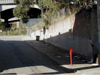
Looking up at the remnants of Rincon Hill from Bryant Street
|
| Landmark Number: |
84 |
| Location: |
Beale Street northwest of Bryant Street, San Francisco, San Francisco County |
| Marker Plaque: |
Official State Plaque |
Description
Rincon Hill was a fashionable neighborhood in the 1860s.
Not much remains of the hill today.
Plaque had been located on Ricon Street northwest of Bryant Street but was moved.
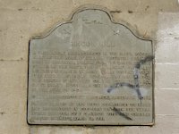
The official state marker plaque marred by
graffiti. The plaque is mounted in the remaining
wall of Saint Mary's Hospital which was built in
1861 but was destroyed in the fire of 1906.
Map
Location and Vicinity Map
Detail Map
View larger map on
OpenStreetMap
or Google Maps

|